
Place, Space and Interconnections of Beaconsfield Flora and Fauna Reserve and the Berwick Views Wetland
-
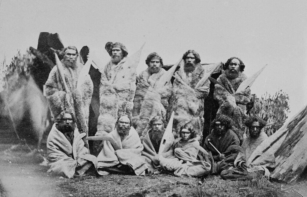
First Nations People
-
Impact of Colonialism
-
Ecosystem Services
-
Invasive Species
-
Food Webs
-
Bats, echidnas and bandicoots

Watch this short video of program highlights.
Australia is home to between 600,000 and 700,000 species, many of which are found nowhere else in the world. About 84 per cent of plants, 83 per cent of mammals, and 45 per cent of birds are only found in Australia. Changes to the landscape and native habitat as a result of human activity have put many of these unique species at risk. Over the last two hundred years many species of plants and animals have become extinct. For the other species of plants and animals whose survival is threatened, a range of management and conservation measures are in place.
This program is filled with an array of hands-on activities, links directly to the Victorian Curriculum and provides students with the opportunity to:
- Discover the history of Berwick and First Nations People
- Look at geographical and historical factors that shape places and influence interconnections.
- Explore the impact of colonisation and key events such as the Gold Rush, the introduction of invasive species and the limitations put on first nations people to care for the land as they once did.
- Understand the ecosystem services of local native species such as bats, bandicoots and echidnas in keeping our environment healthy.
- Explore past, present and future uses of our wetlands, creeks and river systems for humans as well as native plants and animals – and the impact invasive species can have on them.
- Identify the threats and pressures of local flora and fauna and determine what can be done do to help alleviate them.
- Understand the food chain of the wetlands, creek and reserve.
This program ends with a Call to Action
Students will lead a discussion about how Interconnections of places and spaces are affected and/or disrupted by human activities and derive actions they can adopt to minimise their impact on the environment.
This excursion can be run over 3 or 4 hours. The 4 hour option allows for a 30 minute lunch break and extended activities to deepen the learning.
Notes and Inclusions
Certificate and Conservation Code to reinforce learnings
Post event, schools will be issued a Certificate of Participation and Conservation Code for each class which students are encouraged to sign and hang in the classroom as a reminder of their learnings and their commitment to protect the environment. Teachers will also receive a range of free resources and activities so you can continue the learnings/lessons in the classroom.
Equipment supplied by Gould League: Workbook along with all tools and equipment required for activities including fieldwork data collection provided.
Equipment needed by the school: First aid kit, insect repellant, sun screen and PPE including hand sanitiser to kill viruses, bacteria and other micro organisations.
Students needs to bring: Their own snacks, water and lunch, sunscreen, a clipboard, pencil, and a copy of the Gould League student workbook (usually sent 14 days prior to excursion so copies can be made for students) to guide the investigation; bag to take away your rubbish.
Restrictions/Limitations: This Gould League program does not operate on days with a Fire danger rating of Extreme or Catastrophic. On rare occasions, programs may be postponed due to extreme weather predictions involving wind/storms. In both cases, these programs will be rescheduled at the earliest convenience of both parties.
Curriculum Links
Geographical Concepts and Skills: Place, Space and Interconnection
Describe and explain interconnections within places and between places, and the effects of these interconnections (VCGGC087)
Data and information
Collect and record relevant geographical data and information from the field and secondary sources, using ethical protocols (VCGGC088)
Represent the location of places and other types of geographical data and information in different forms including diagrams, field sketches and large-scale and small-scale maps that conform to cartographic conventions of border, scale, legend, title, north point and source; using digital and spatial technologies as appropriate(VCGGC089)
Geographical Knowledge: Factors that shape places and influence interconnections
Impacts of bushfires or floods on environments and communities, and how people can respond (VCGGK095)
Environmental and human influences on the location and characteristics of places and the management of spaces within them (VCGGK096)
Factors that influence people’s awareness and opinion of places (VCGGK097)
Science Understanding: Biological sciences
Habitats can be described by their physical conditions; changing the physical conditions of a habitat, including by human activity, may affect the growth and survival of organisms VC2S6U01
The Victorian Curriculum F-10 content elements are © VCAA, reproduced by permission. Victorian Curriculum F-10 elements accurate at time of publication. The VCAA does not endorse or make any warranties regarding this resource. The Victorian Curriculum F-10 and related content can be accessed directly at the VCAA website.