
FIRE and the FOREST: Level 5 – 6
-
Forest
-
Human Impacts
Excursion Program Overview
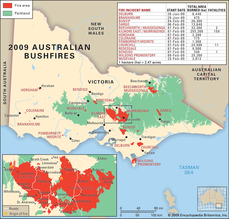
Australia is a dry and fire-prone country. The geographical location of Victoria, its vegetation and climate of mild winters followed by hot summers combine to produce one of the most fire-prone environments in the world. Fires have occurred frequently throughout our history and provide a threat to plants and animals of the forest as well as the people who live and work in these areas.
As part of this Gould League excursion to the Toolangi State Forest and Kinglake, students will:
- Understand how and why forest fires begin and progress so quickly.
- Investigate the Forest Fire Index and warning system of the BOM.
- Reflect on Victoria’s Black Saturday Fires.
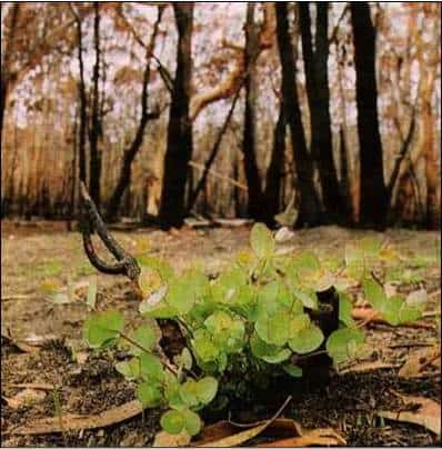
- Explore the ways that plants and animals of the forest have adapted to their environment and the threat of fire over time.
- Complete a fieldwork sketch of the fuel load in the forest.
- Mind map causes and effects of fire and what is being done to protect forests, people and property from future fires.
- Reflect on changes made after Victoria’s Black Saturday Fires and the impact of global citizenship.
- Look at ways in which Forest Management, DELWP, CFA and the community work to prevent, prepare, fight and limit the extent of bushfires.
Inclusions and Notes
Equipment supplied by Gould League: Workbook and all tools required for fieldwork data collection.
Equipment needed by the school: A bus (which is required to remain with the group at all times). First aid kit, sun screen, insect repellent and PPE including hand sanitiser to kill viruses, bacteria and other micro organisations.
Please note that our Gould League educators will travel on your bus for the duration of your program time. We ask schools to ensure when booking coaches that 1 one seat is allocated for each group booked as they will provide commentary on the bus to students and guide the bus drivers. Please advise the Bookings Manager if there is no room on the coach for our educators, and travel fee of $0.88 per km will be added to your final invoice. This amount will vary according to the activities undertaken on the day which can vary due to late arrival of buses and or local weather conditions. Travel cost to the Memorial and Masons Falls at Kinglake is $62 ($35.20 if only to memorial). This covers the cost of one vehicle only as Gould League Educators will carpool.
Student needs to bring: Their own water and lunch, sunscreen, a clipboard, pencil, and a copy of the Gould League workbook (usually sent 14 days prior to excursion so copies can be made for students) to guide the forest investigation; bag to take away your rubbish.
Restrictions: This Gould League program is delivered in the Toolangi State Forest, in the North Central Fire District and does not operate on days with a Fire danger rating of Extreme or Catastrophic. On rare occasions, programs may be postponed due to extreme weather predictions involving wind/storms. In both cases, these programs will be rescheduled at the earliest convenience of both parties.
Programs however DO operate during wet/snowy weather. Please contact us to discuss the best timing to optimize your group’s experience and ensure suitable clothing and footwear for the conditions predicted. Plan for wet weather from April-October, and expect temperatures at least 5 degrees colder than suburban Melbourne.
Curriculum Links
Science as a human endeavour
Scientific understandings, discoveries and inventions are used to inform personal and community decisions and to solve problems that directly affect people’s lives (VCSSU073)
Biological Sciences
Living things have structural features and adaptations that help them to survive in their environment (VCSSU074)
The growth and survival of living things are affected by the physical conditions of their environment (VCSSU075)
Science Inquiry Skills – Recording and processing
Construct and use a range of representations, including tables and graphs, to record, represent and describe observations, patterns or relationships in data (VCSIS085)
Analysing and evaluating
Compare data with predictions and use as evidence in developing explanations (VCSIS086)
Suggest improvements to the methods used to investigate a question or solve a problem (VCSIS087)
Communicating
Communicate ideas and processes using evidence to develop explanations of events and phenomena and to identify simple cause-and-effect relationships (VCSIS088)
Geographical knowledge
Impacts of bushfires or floods on environments and communities, and how people can respond (VCGGK095)
Geographical Knowledge: Factors that influence people’s awareness and opinion of places
Identifying factors that influence people’s awareness and opinions of places, for example, the media, significant known events, proximity to places and personal relationships with places (VCGGK097)
Geographical Data and Information
Collect and record relevant geographical data and information from the field and secondary sources, using ethical protocols (VCGGC088)
Represent the location of places and other types of geographical data and information in different forms including diagrams, field sketches and large-scale and small-scale maps that conform to cartographic conventions of border, scale, legend, title, north point and source; using digital and spatial technologies as appropriate (VCGGC089)
Interpret maps and other geographical data and information using digital and spatial technologies as appropriate, to develop identifications, descriptions, explanations and conclusions that use geographical terminology (VCGGC090)
Historical significance
Explain the significance of an event and an individual or group that influenced change in the Australian colonies and in Australian society since Federation (VCHHC087)
The Victorian Curriculum F-10 content elements are © VCAA, reproduced by permission. Victorian Curriculum F-10 elements accurate at time of publication. The VCAA does not endorse or make any warranties regarding this resource. The Victorian Curriculum F-10 and related content can be accessed directly at the VCAA website.